


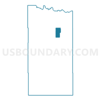
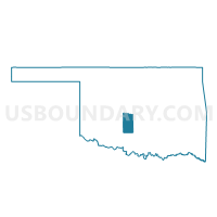
Voting District 14, Grady County, Oklahoma
About
Outline

Summary
| Unique Area Identifier | 654058 |
| Name | Voting District 14 |
| County | Grady County |
| State | Oklahoma |
| Area (square miles) | 11.13 |
| Land Area (square miles) | 11.12 |
| Water Area (square miles) | 0.02 |
| % of Land Area | 99.86 |
| % of Water Area | 0.14 |
| Latitude of the Internal Point | 35.16908450 |
| Longtitude of the Internal Point | -97.81095150 |
Maps

Graphs
Select a template below for downloading or customizing gragh for Voting District 14, Grady County, Oklahoma


Neighbors
Neighoring Voting District (by Name) Neighboring Voting District on the Map
- Voting District 21, Grady County, OK
- Voting District 25, Grady County, OK
- Voting District 38, Grady County, OK
- Voting District 39, Grady County, OK
- Voting District 40, Grady County, OK
Top 10 Neighboring County Subdivision (by Population) Neighboring County Subdivision on the Map
Top 10 Neighboring Elementary School District (by Population) Neighboring Elementary School District on the Map
Top 10 Neighboring Unified School District (by Population) Neighboring Unified School District on the Map
- Tuttle Public Schools, OK (8,069)
- Bridge Creek Public Schools, OK (7,737)
- Amber-Pocasset Public Schools, OK (1,840)
Top 10 Neighboring State Legislative District Lower Chamber (by Population) Neighboring State Legislative District Lower Chamber on the Map
- State House District 47, OK (41,973)
- State House District 51, OK (37,430)
- State House District 65, OK (35,531)